Tuesday, November 24, 2020

 Lab 5


This lab discovers the classifications in EDRAS. We focused on supervised and unsupervised classifications mostly. We learned how to create are own signatures for water and roads on this particular project, recoding with unique classes (urban, road, grass, deciduous forest, mixed forest, fallow, agriculture, and water) and lastly calculating the area of each class. Once we finished this we put the map in ArcGIS and created a map layout. 

Tuesday, November 17, 2020


                                                                               LAB 4


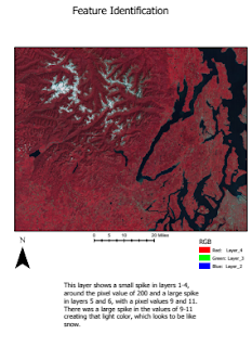
During this lab we used EDRAS and ARGIS to manipulate the way an image can look through different color combinations. We adjusted the RGB's of the image to successfully show the points we were trying to. One could also use the the histogram to change how you see the image.

Wednesday, November 11, 2020

                                                                          LAB 3


In this lab we began to learn the concepts of ERDAS Imagine. Some main things we learned was how to add raster data, see more than one view point, adding rows in the attribute table, and different symbology. Once we made the map we transferred it into GIS and used our prior knowledge to make a map. 


LAB 1


  In the first deliverable a polygon class features were made to highlight spots of different tones and different textures. The tone is highlighted in the legend as black and the texture in red. The polygons each had text to describe the lightest/darkest and finest/most-course areas. In the second map a point class features were made to show t features like shadows, shapes, and association them with what they actually were. Text was added to show what each feature was, as well as a legend.